As Little As 1 Percent Of LiDAR Can Be Used To Effectively Map And Estimate Urban Tree Biomass
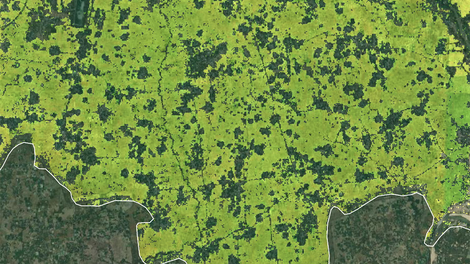
Light Detection and Ranging (LiDAR) data is being increasingly used as an effective alternative to conventional optical remote sensing to accurately estimate aboveground forest biomass ranging from individual tree to stand levels. Recent advancements in LiDAR technology have resulted in higher point densities and improved data accuracies accompanied by challenges for procuring and processing voluminous LiDAR data for large-area assessments. New research from Kunwar Singh (2014 graduate of the PhD program in FER and Center alumnus), Gang Chen, James McCarter, and Ross Meentemeyer demonstrates how as little as 1 percent of original LiDAR data can be used to effectively map urban tree biomass with minimal impact on accuracy of biomass estimates. Their research is published in ISPRS Journal of Photogrammetry and Remote Sensing and available online using the link below.
Reference:
Singh, K.K., Chen, G., McCarter, J.B., and Meentemeyer, R.K. (2015). Effects of LiDAR point-density and landscape context on estimates of urban forest biomass. ISPRS Journal of Photogrammetry and Remote Sensing. 101: 310-322.
Abstract:
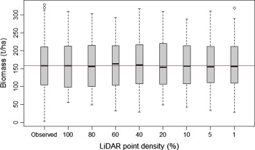
Light Detection and Ranging (LiDAR) data is being increasingly used as an effective alternative to conventional optical remote sensing to accurately estimate aboveground forest biomass ranging from individual tree to stand levels. Recent advancements in LiDAR technology have resulted in higher point densities and improved data accuracies accompanied by challenges for procuring and processing voluminous LiDAR data for large-area assessments. Reducing point density lowers data acquisition costs and overcomes computational challenges for large-area forest assessments. However, how does lower point density impact the accuracy of biomass estimation in forests containing a great level of anthropogenic disturbance? We evaluate the effects of LiDAR point density on the biomass estimation of remnant forests in the rapidly urbanizing region of Charlotte, North Carolina, USA. We used multiple linear regression to establish a statistical relationship between field-measured biomass and predictor variables derived from LiDAR data with varying densities. We compared the estimation accuracies between a general Urban Forest type and three Forest Type models (evergreen, deciduous, and mixed) and quantified the degree to which landscape context influenced biomass estimation. The explained biomass variance of the Urban Forest model, using adjusted R2, was consistent across the reduced point densities, with the highest difference of 11.5% between the 100% and 1% point densities. The combined estimates of Forest Type biomass models outperformed the Urban Forest models at the representative point densities (100% and 40%). The Urban Forest biomass model with development density of 125 m radius produced the highest adjusted R2 (0.83 and 0.82 at 100% and 40% LiDAR point densities, respectively) and the lowest RMSE values, highlighting a distance impact of development on biomass estimation. Our evaluation suggests that reducing LiDAR point density is a viable solution to regional-scale forest assessment without compromising the accuracy of biomass estimates, and these estimates can be further improved using development density.
The ISPRS Journal of Photogrammetry and Remote Sensing (P&RS) is the official journal of the International Society for Photogrammetry and Remote Sensing (ISPRS). The Journal provides a channel of communication for scientists and professionals in all countries working in the many disciplines that employ photogrammetry, remote sensing, spatial information systems, computer vision, and related fields. The Journal is designed to serve as a source reference and archive of advancements in these disciplines.
More info: http://www.journals.elsevier.com/isprs-journal-of-photogrammetry-and-remote-sensing/
- Categories: