Pest or Pathogen Spread (PoPS) Model 2.0.0 Released
Developers at the Center for Geospatial Analytics have announced the release of PoPS 2.0.0, the latest official version of the Center’s signature open source system for forecasting the spread of insect pests and disease and for testing control strategies.
PoPS stands for Pest or Pathogen Spread, requires no spatial modeling experience to run, and can be used to forecast the spread of practically any species.
The new release of PoPS features several improvements:
- Spread can now be simulated via networks, such as railroads and roads, using a network dispersal kernel. The new kernel permits more mechanistically simulating anthropogenic drivers of spread rather than using random directions to simulate accidental, human-mediated long-distance dispersal.
- Model outputs now include an indication of how “infective” each pixel is across a landscape, i.e., how many dispersers are produced by a particular pixel vs. how many of them successfully establish in other pixels. This new metric is particularly useful for tracking source infections for pathogen spread and identifying nodes in a network that are hotspots for pest dispersal.
- Code improvements have reduced computation time, making the model run about four times faster.
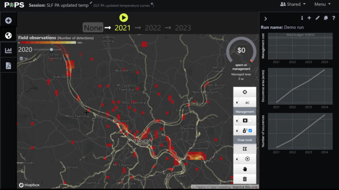
The new release (v2.0.0) features an R package (rpops) consisting of a process-based model to predict spread, as well as calibration and validation features. The release also includes a GRASS GIS module (r.pops.spread) for the process-based model, with static and interactive tutorials available in Jupyter Notebook that permit trying the model before installing it.
To predict the spread of their species of interest, users provide PoPS with a host raster and the locations and timing of species detections, as well as information about the species’ biology. The model then predicts when and where a species is likely to establish, based on where it is already found, its dispersal capability, the locations of suitable hosts, and the impact of precipitation and temperature on its survival and reproduction. Model outputs include predicted infested or infected area, number of infested or infected hosts, the probability of the pest or pathogen escaping quarantine, and spread in the cardinal directions.
PoPS is uniquely suited for examining the potential impact of management strategies on spread, allowing users to compare a forecast without management to forecasts based on “what-if” scenarios that treat or remove hosts. Users can even simulate management in multiple years to examine the cumulative impacts of intervention across time (learn more from the 2020 publication “Geospatial simulation steering for adaptive management” in Environmental Modelling and Software).
The PoPS development team, led by research scholar Chris Jones and software engineer Vaclav Petras, are using PoPS to support government agencies seeking strategies to control invasive insect pests and plant pathogens. The network kernel featured in PoPS 2.0 was specifically designed after discussions with personnel at the US Department of Agriculture, to support modeling the spread of spotted lanternfly (Lycorma delicatula).
The PoPS modeling framework was first described in the 2021 publication “Iteratively forecasting biological invasions with PoPS and a little help from our friends” in Frontiers in Ecology and the Environment. PoPS 2.0 was used to forecast the spread of spotted lanternfly across the United States in the 2022 publication “Spotted lanternfly predicted to establish in California by 2033 without preventative management” in Communications Biology.