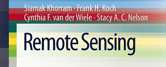
All News

A presenter showing an example of geospatial modeling

Jun 22, 2015

Integrating Free And Open Source Solutions Into Geospatial Science Education At NC State

While open science perspectives have been increasingly adopted in research and industry, the trend is much less reflected in university educational programs. A new open access publication by Center researchers…

A photo of Jared Berger giving a remote presentation

Jun 3, 2015

MGIST Graduates Team With Community Partner IntraHealth International To Develop Critical Spatial Decision Support Tools

Three recent graduates of the MGIST program received special invitations from community partner IntraHealth International, based in Chapel Hill, NC, to present their geospatial applications to agency representatives.  Jared Berger,…

May 18, 2015

Building Adaptive Capacities of Human Communities in Minnesota

Center Faculty Fellow Jordan W. Smith and graduate students Karly Bitsura-Meszaros and Allie McCreary are working on a participatory research project focused on building the adaptive capacity of natural resource…

A photo of Jenny Holder

May 6, 2015

MGIST Student Jenny Holder Accepted To Prestigious NASA DEVELOP National Program

MGIST student Jenny Holder has been accepted to the national NASA DEVELOP Program for their summer 2015 term. This highly competitive program fosters an interdisciplinary research environment, where applied science research…

A picture of citizen scientists collecting data to track Sudden Oak Death

May 5, 2015

Citizen Science Helps Predict Risk Of Emerging Infectious Disease

Citizen science with volunteered geographic information is playing a critical role in tracking and predicting the spread of Sudden Oak Death (SOD) disease according to new research published by Center…

A logo for the North Carolina State University Center for Geospatial Analytics Industry Experience Program

Apr 23, 2015

New “Industry Experience Program” Immerses Students In Hands-On Geospatial Traineeships While Completing Their Degrees

The Center for Geospatial Analytics is excited to announce the launch of the CGA Industry Experience Program (IEP). This new program will give graduate students the opportunity to immerse themselves…

A photo of Dillon Whalen

Apr 13, 2015

Whalen Dillon Receives Travel Award To Attend Landscape Ecology World Congress

Center PhD student Whalen Dillon (Dept. of Forestry and Environmental Resources) has been selected to receive a $500 Student Travel Award sponsored by the US Regional International Association for Landscape Ecology…

A photo of Francesco Tonini

Apr 13, 2015

Francesco Tonini Receives NASA-MSU Professional Enhancement Award

Center postdoctoral scholar Francesco Tonini has been selected as a recipient of the NASA-MSU Professional Enhancement Award. These awards are jointly supported by NASA and Michigan State University and recognize…

A photo of children at the NC State Veterinary Medicine open house

Apr 1, 2015

Tangible Landscape Raises Geospatial Awareness At NC State College of Veterinary Medicine Open House

The Center’s Open Source Geospatial Research and Education Lab was invited to showcase the Tangible Landscape technology at the NC State College of Veterinary Medicine Open House on March 28. Visitors of…

A visualization of shoreline change from 2004 to 2014

Mar 20, 2015

People Perceive Coastal Change Processes As More Severe When Processes Visualized In Aerial Photographs

New research by Rosemary Keane (PRTM PhD Student) and Jordan W. Smith (CGA Faculty Fellow) explores the ability of different geovisualization mediums such as digital elevation models (DEM) and aerial…