Tours of Geovisualization Lab Spark Discovery and New Partnerships
When you step into the Geovisualization Lab at the Center for Geospatial Analytics at NC State, maps leap off computer screens onto touchable, interactive displays. Virtual reality headsets let you enter landscapes and experience how it would feel to be there. Landforms respond to the motions of your hands, and joysticks let you select what you like most in an environment. Impressive to see, these technologies are also key to center research, as scientists use cutting-edge visualization tools to study and solve complex environmental problems.
Tools and technologies develop at lightning speed, and so the center welcomes many guests to visit the lab––to see, to learn, and to collaborate. The lab hosts about 50 formal and informal tours a year, for local community groups, visiting scholars, guest lecturers, dignitaries, and more. Some visitors come to watch the center’s cutting-edge tools at work, others visit to build partnerships with the researchers using those tools, and all enjoy the interactive live demos and displays.
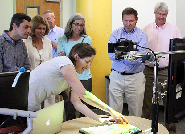
In June for instance, dozens of students from the College-2-Career Preparation & Readiness program visited the Geovisualization Lab as part of college prep activities across the university. Here at the center, they enjoyed gathering around a large projected map to watch a simulated fire crawl across a landscape and react to alternative management actions; they took turns donning a headset to experience a 360º view of a plaza in downtown Raleigh and feel how the scene changes with more planted trees; and they were captivated by molding polymer-enriched sand to sculpt landforms and see how simulated water flows over them.
“I am having too much fun with this,” quipped one student. As they sculpted landscapes by hand and explored scenes with virtual reality, the students also learned why the center uses these technologies, eagerly asking questions about how the tools worked and what they can do.
For example, the Immersive Virtual Environment allows graduate students in the College of Design to better understand how people link feelings of personal safety and relaxation with the number of trees in city plazas and parks. This can help city planners design public spaces that make local residents feel most comfortable. Meanwhile, Tangible Landscape helps researchers develop what-if scenarios to explore how landscape-scale changes affect places where we live and work. For instance, how and where would water pool in a new housing development after a rainstorm, showing where drains are most needed?
Between visits by the students in June, the center also hosted a group of scholars from the UNC Gillings School of Global Public Health and RTI International, at the request of Dr. Aaron Hipp. Dr. Hipp is a faculty fellow at the center who recently discussed his research on place and active living for the weekly local radio program Radio In Vivo. Dr. Marian McCord, Associate Dean for Research in the College of Natural Resources, and Dr. Myron Ford, head of the Department of Parks, Recreation and Tourism Management participated in this tour as well. As they watched live demos of the Geovisualization Lab’s Tangible Landscape, Immersive Virtual Environments, and GazeGIS eye-tracking tools, the group discussed wide-ranging applications of these technologies and potential uses for exploring and improving human health.
As well as giving tours and performing innovative research, center scientists also take Geovisualization Lab displays “on the road,” exhibiting these developing technologies and their applications at conferences and workshops. Most recently, Associate Director of Geovisualization Dr. Helena Mitasova, Faculty Fellow Dr. Laura Tateosian, and their teams sponsored a table showcasing GazeGIS and other center research at FOSS4G, a geospatial conference held this past May at the Raleigh Convention Center.
With so many interactive technologies being developed by scientists and designers at the Center for Geospatial Analytics, our tours, live demos, and displays highlight key ways center researchers are engaging with community partners to both think and do.
- Categories: