
2022

Deja Perkins - Center for Geospatial Analytics at NC State University

Feb 23, 2022

Deja Perkins Recognized as One of North Carolina’s Black STEM Leaders

Geospatial Analytics Ph.D. student Deja Perkins is co-organizer of #BlackBirdersWeek and the BlackAFinSTEM Collective.

Map of the United States showing predicted average flood damage risk by state or district - Center for Geospatial Analytics at NC State University

Feb 22, 2022

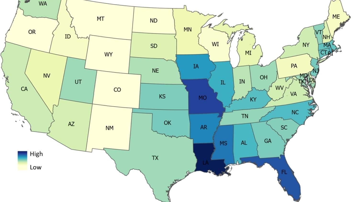
Study: U.S. Flood Damage Risk Is Underestimated

A research team led by Geospatial Analytics Ph.D. student Elyssa Collins used artificial intelligence to predict where flood damage is likely to happen in the conterminous United States, suggesting that recent flood maps from the Federal Emergency Management Agency do not capture the full extent of flood risk.

Raja Das stands next to his poster - Observing Landslide Events from Multi-Satellite Sensors - Center for Geospatial Analytics at NC State University

Feb 10, 2022

Observing Landslide Events from Multi-Satellite Sensors

Geospatial Analytics Ph.D. student Raja Das is advancing the use of satellite imagery and machine learning to map the impacts of landslides and flooding, comparing the utility of different spatial resolutions and algorithms.

Presentation Title: Forecasting Prescribed Fire Smoke in Southern Appalachian Communities - Future Fire Use and Wildland Urban Interface Communities in Western North Carolina - Center for Geospatial Analytics at NC State University

Feb 9, 2022

Future Fire Use and Wildland Urban Interface Communities in Western North Carolina

Geospatial Analytics Ph.D. student Kate Jones is working with land managers to develop scenarios of future prescribed fire management and predict the effect of different strategies on the distribution of downwind smoke through space and time.

Izzi Hinks presents at AGU - Efficiently Monitoring Small Farms From Space - Center for Geospatial Analytics at NC State University

Jan 20, 2022

Efficiently Monitoring Small Farms from Space

Geospatial Analytics Ph.D. student Izzi Hinks developed an approach to optimally augment publicly available satellite imagery with high-resolution commercial data to track crop development on small farms.

Collage of Images - 2021 Year in Review - Center for Geospatial Analytics at NC State University

Jan 7, 2022

2021 Year in Review

What were our most popular news stories from 2021? Check out the top ten news blog posts from the Center for Geospatial Analytics.

a child at a playground - KABOOM! Launches Playspace Mapping Program in Colorado - Center for Geospatial Analytics at NC State University

Jan 6, 2022

KABOOM! Launches Playspace Mapping Program in Colorado

New research co-led by Assoc. Director Aaron Hipp will evaluate the locations and quality of playspaces to address racial and economic gaps in access to quality spaces for play.