In the Battle Against a Spreading Forest Disease, Strategy Matters
This fall, a research team from the Center for Geospatial Analytics at North Carolina State University traveled to Oregon to take an important step in the fight against sudden oak death, a tree disease that is threatening both forest and economic health in the region.
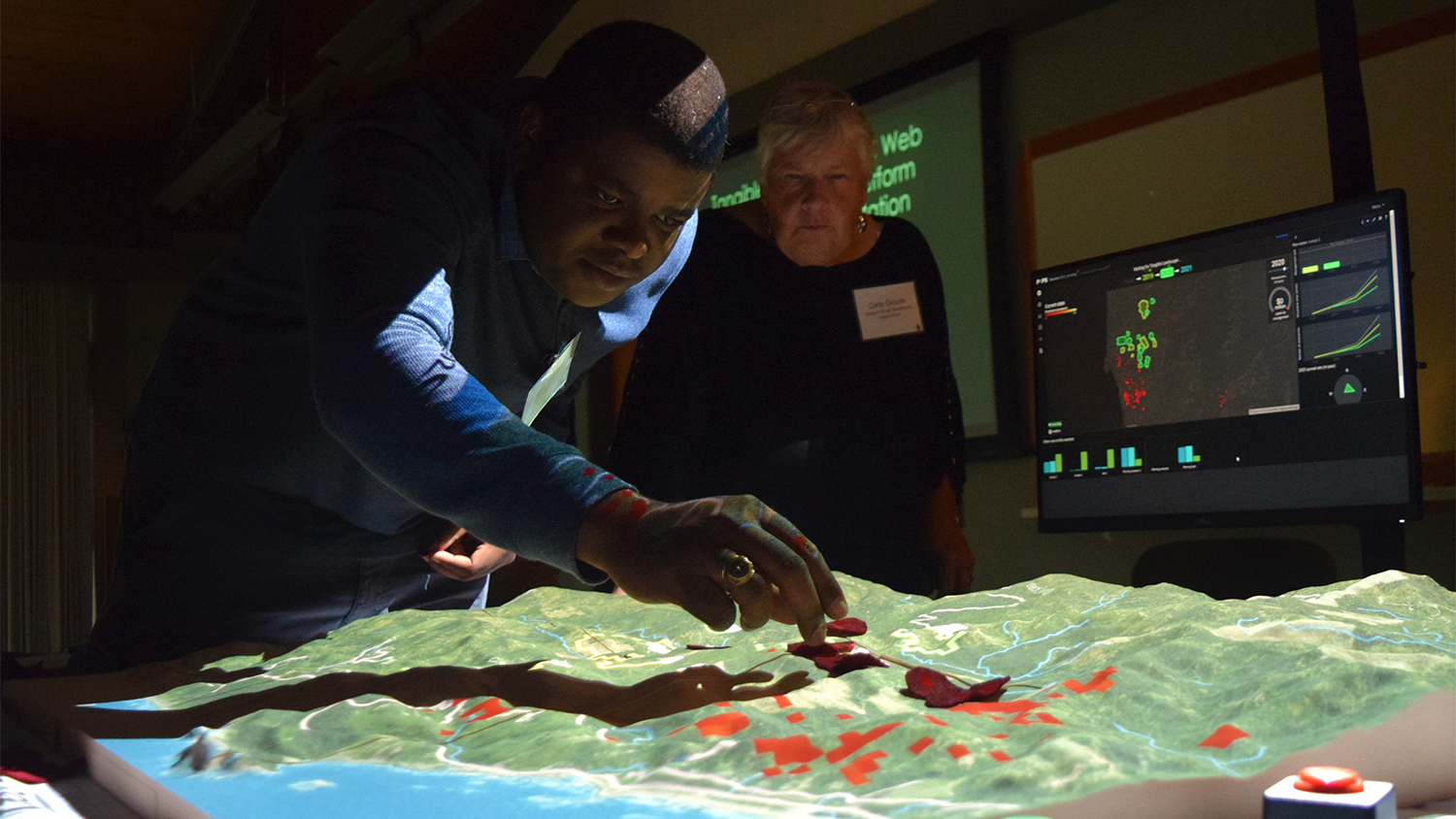
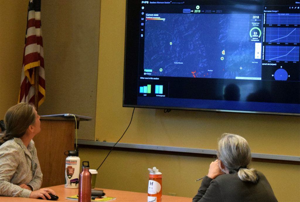
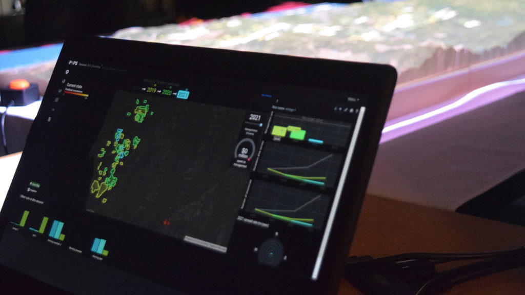
At a gathering of the Oregon Sudden Oak Death Task Force in Marion County in September, the team rolled out two kinds of user interface for a new forecasting technology called PoPS––Pest or Pathogen Spread––that can help formulate management strategies.
Over thirty meeting attendees from government, academia, nonprofit groups and the timber industry experimented with the two interfaces and offered their feedback on PoPS, as they tested different “what-if” scenarios to curb disease spread.
One interface uses Tangible Landscape technology with a touchable, interactive surface to run PoPS on a local computer, while the other is a web platform that runs PoPS in the cloud. The web platform and Tangible Landscape both run a sophisticated computer simulation that uses information about existing infections, locations of host trees and weather conditions to predict the spread of sudden oak death disease. The PoPS forecasting system allows users to interact with that simulation, and practice spending a realistic budget to try to prevent the spread. Both interfaces store those management choices in a cloud-based database and share a visualization dashboard for easily comparing the effectiveness of different strategies.
“As we continue to develop these technologies, getting feedback is very helpful,” says Devon Gaydos, a doctoral student in the Department of Forestry and Environmental Resources at NC State advised by the Center for Geospatial Analytics’ director, Ross Meentemeyer. Gaydos is spearheading the research team’s efforts to engage stakeholders with these disease modeling tools.
To understand how best to help decision-makers, she says, asking them what they prefer in a decision-support tool and seeing what management scenarios they envision are essential.
Comments received during the workshop will guide technology improvements as well as future research into participatory modeling approaches that can help decision-makers in Oregon and elsewhere explore their options.
Tangible Landscape involves physically molding a touchable surface to interact with the computer simulation, whereas the web platform is an online portal that uses a traditional computer mouse to navigate.
Overall, attendees were impressed with the capabilities of both technologies, and found working through the scenarios helpful to their own understanding of the disease. One participant observed that the tools were “extremely useful from a planning perspective and very effective…for collaboration and prioritization.” Another commented, “The Tangible Landscape really gets stakeholders talking and engaging in a fun and constructive manner.”
A participant who knew little about sudden oak death disease before the workshop called the experience “eye opening,” while another observed that interacting with the computer model clearly demonstrated how some management approaches are more effective than others, given the way that the disease spreads.
Some stakeholders are now hoping to take their newfound knowledge to the Oregon state legislature, with realistic scenarios and budget estimates from their use of the center’s tools, to seek funding to combat the disease. Others are also interested in applying the center’s technologies to strategizing the control of invasive gorse plants in Oregon and rapid ohia death disease in Hawai’i.
“The beauty of these geospatial decision analytics that our center is developing,” explains Meentemeyer, “is that they can be applied to a whole host of challenges.”
The research team developing these tools includes Gaydos; research associate Chris Jones (lead developer of PoPS); Geospatial Analytics doctoral students Garrett Millar, Kellyn Montgomery and Nick Kruskamp; geospatial research software engineers Vaclav Petras and Anna Petrasova; postdoctoral scholar Wanwan Liang; and center director Meentemeyer.
At the workshop, they worked closely with representatives from:
- federal government
- US Department of Agriculture’s Animal and Plant Health Inspection Service
- Bureau of Land Management
- US Fish and Wildlife
- Natural Resources Conservation Service
- US Senate
- state government
- Business Oregon
- Oregon Department of Forestry
- Oregon Legislature
- Oregon Department of Agriculture
- Oregon Department of Transportation
- local government
- City of Gold Beach
- Curry County
- Association of Oregon Counties
- tribal government
- Coquille Tribe
- timber groups
- Oregon Forestry Industry Council
- Rayonier
- South Coast Lumber
- nonprofits and collaboratives
- Wild Rivers Land Trust
- Southwestern Oregon Workforce Investment Board
- South Coast Business Employment Corporation
- Oregon Small Woodlands Association
- Coos County Forest Protective Association
- academic institutions
- Oregon State University (OSU)
- OSU Extension Service
The visit followed up on a pilot workshop conducted two years ago with foresters, forest pathologists and epidemiologists from the Oregon Department of Forestry, Oregon State University and U.S. Forest Service.
“This is a really diverse group of stakeholders,” says Gaydos, “but they work very well together and they have for a while. They have a common goal, and that’s not always the case with environmental decision-making.”