Custom Geospatial Tool Helps National Park Service Better Predict Fire Risk on Florida’s River of Grass

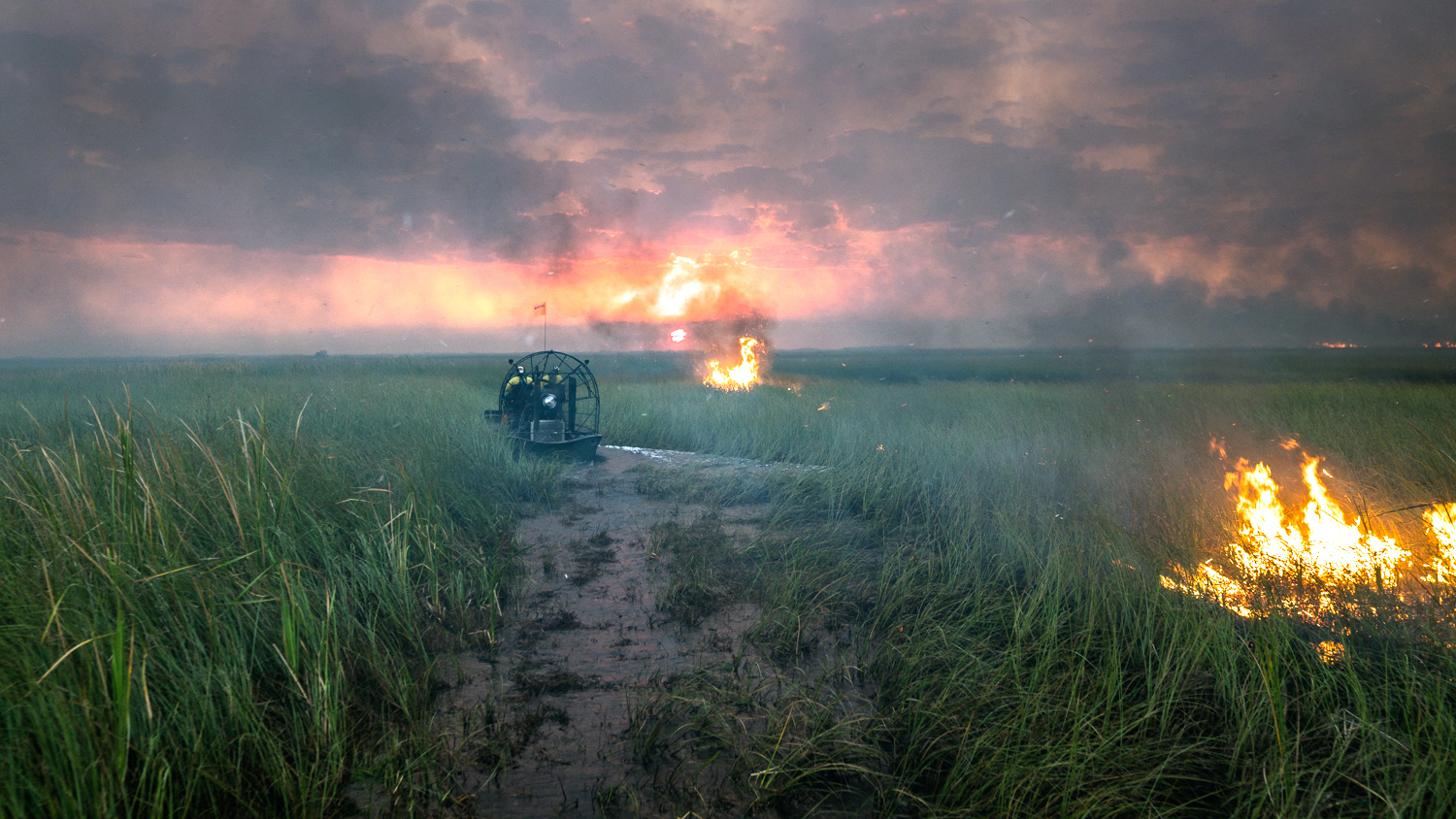
In southern Florida, wildfires ignited by lightning are a common occurrence, and water depths in the region’s wet prairies and sawgrass marshes have a big impact on how readily the plants will burn. For fire managers, using water levels to predict fire behavior and spread has always been a challenge: helicopter flights to survey constantly changing conditions are expensive and time-consuming, and no automated system has existed for identifying areas of high risk.
Now, a custom mapping tool developed by researchers at the Center for Geospatial Analytics at North Carolina State University is helping the National Park Service to quickly and easily map water levels––and forecast fire risk.
“The ultimate goal is to let fire managers look at a map and make a decision pretty quickly about the danger of fire,” says James Sullivan, Fire Management Officer at Everglades National Park, and acting FMO at Big Cypress National Preserve.
Last year, Sullivan approached center research associate Justin Shedd about using geospatial analytics to assess fire activity over wetlands. Shedd specializes in applying geospatial problem-solving to fire management for the National Park Service (NPS), and “he was able to bring in the right people to get all of the info and develop the product,” Sullivan says.
Under the direction of center faculty fellow Jelena Vukomanovic, postdoctoral scholar Krishna Singh coded a framework dubbed Fire Hydro that is now allowing NPS to “conduct more prescribed fire and allow more natural fires to burn, predict fire spread and behavior, and better allocate resources,” Shedd explains.
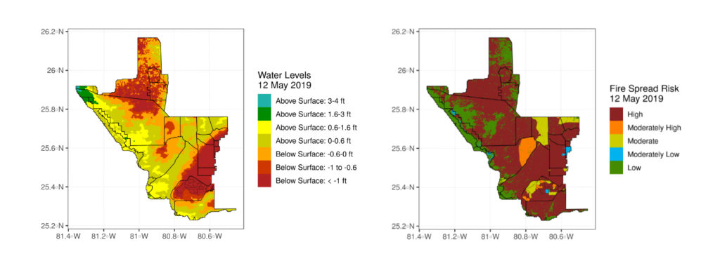
Fire Hydro harnesses data from hundreds of water gages part of the Everglades Depth Estimation Network (EDEN), and overlays those data with geospatial data of vegetation and recent fire history––all to generate easy-to-use maps of fire risk.
The project “leveraged existing data to address a real-world problem,” Shedd says, and resulted in a customized “out-of-the box, ready-to-run” solution for NPS to use.

How does Fire Hydro work?
Key to building Fire Hydro was ensuring that the system could be easily operated by NPS staff, and therefore would be readily used, Shedd explains. Over the course of several months, NPS and the Center for Geospatial Analytics worked closely to refine the approach.
Several sources of data were used as inputs to the Fire Hydro system: water depth maps based on water gage information and maps of vegetation divided into ten categories based on an inventory of 96 vegetation types across the landscape. Sullivan then supplied center researchers with a table of “water level thresholds,” indicating the potential for each vegetation category to be available for ignition or maintain the spread of a wildfire at different water levels.
Fire Hydro was designed to run using the free modeling software R and generates predictions of ignition risk by combining information from the maps and the table, automating calculations through a series of “if/then” statements: i.e., if the vegetation category in a particular location is X and the water level there is Y, then the risk level is Z.
The system outputs maps like the ones above to show the spatial extent of each level of ignition risk, from low to high.
How is the National Park Service using Fire Hydro?
Since the tool was implemented by NPS in February 2019, it has already been instrumental to fire managers, both for containing wildfires and for planning prescribed fires.
This past spring, a human-caused wildfire began near Highway 41, a thoroughfare that passes right through the Everglades. “We knew it would be an aggressive fire, moving quickly and burning hot,” Sullivan says, “but we also knew that it would go out on its own due to the water” levels that were relatively high in the surrounding area.
The wildfire posed risks to buildings in its path, but thanks to Fire Hydro, “we could make very quick decisions about which structures to protect and where we didn’t have to expend resources” because the fire would extinguish itself before it posed a threat, Sullivan explains. The water level and fire risk maps helped NPS staff to not only save time and money but also keep firefighters out of harm’s way. “It definitely helps with making decisions,” he says.
In mid-June, Sullivan and his staff used Fire Hydro in a different way: to plan prescribed fires across some 1,700 acres of the Everglades to restore an endangered, and highly fire-dependent, ecosystem known as the pine rocklands. Unlike the Everglades’ wet prairies and sawgrass marshes, this forested ecosystem is typically quite dry, found at higher elevations than the wetlands. With Fire Hydro, “we were able to burn these units without really worrying about the fire getting outside of them,” Sullivan explains. He and his staff could tell from their maps that water levels would keep the fire from spreading beyond where they wanted it to go.
At another point in the summer, the fire staff ceased prescribed burning altogether because of very dry conditions. “We saw that over 90% [of vegetation] was ready to burn throughout the Park,” Sullivan says, and that “allowed us to stop burning in a good amount of time so we wouldn’t risk an escaped prescribed fire.”
That same season, south Florida experienced a solid week of rain that promised the possibility of lower fire risk, at least for a while, by increasing levels of standing water across the Everglades. But Fire Hydro told a different story, and warned fire managers not to let their guard down. “We got rain,” Sullivan recalls, “but the maps showed no change in water level––it turns out, the water was just getting absorbed.” As the ground and vegetation soaked up the rain, they left little extra for combatting fire. “We were out of fire severity and then right back in again,” he says.
The maps generated by Fire Hydro provide a quantitative picture of conditions in the Everglades, supplementing human observations to support “making decisions with science-based information,” Sullivan says. They also help with conveying needs for fire preparedness funding to the national NPS office. “This is exactly what the tool is set up to do––allow fire managers to make decisions and to pass that information up the chain of command, so that they can see what we’re seeing in South Florida.”


