Capturing Changes in Wetlands from Space
Editor’s note: Each semester, students in the Geospatial Analytics Ph.D. program can apply for a Geospatial Analytics Travel Award that supports research travel or presentations at conferences. The following is a guest post by travel award winner Jenna Abrahamson as part of the Student Travel series.
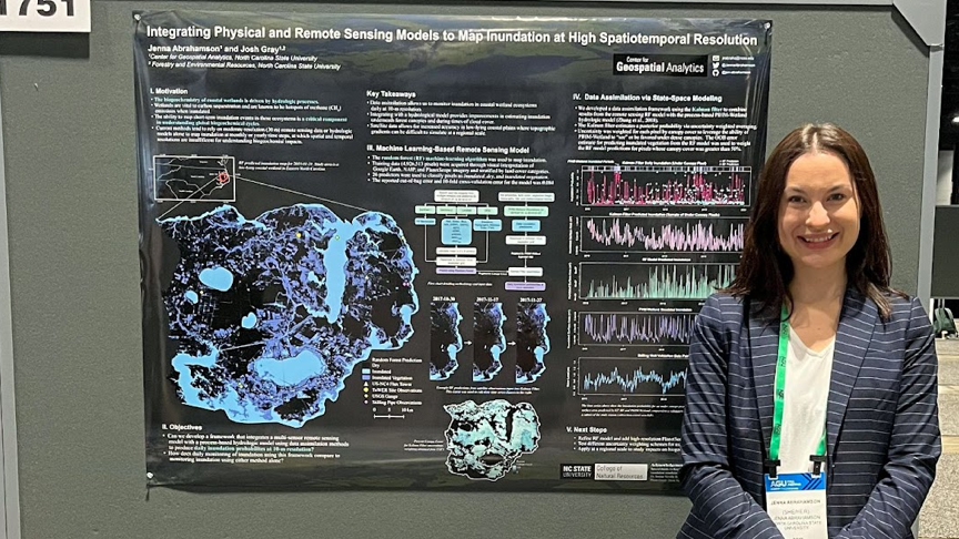
The American Geophysical Union (AGU) Annual Meeting is one of the most influential events in the world dedicated to the advancement of Earth and space sciences. Held annually, the conference draws together >25,000 researchers, scientists, educators, students, policymakers and journalists to better understand our planet and environment. I was honored to receive a travel award from the Center for Geospatial Analytics to present my research at AGU’s 2022 Fall Meeting held in Chicago December 12–16, 2022. I presented my research on “Integrating Physical and Remote Sensing Models to Map Inundation at High Spatiotemporal Resolution” in the Biogeosciences Remote Sensing of Wetlands Dynamics poster session.
Biogeochemical processes are strongly influenced by hydrology, particularly in coastal wetlands where drastic changes in inundated (i.e., flooded) areas occur over short time scales. Wetlands are vital for storing carbon and are known hotspots of methane (CH4) emissions when inundated. Methane emissions are sharply increasing, with natural emission sources such as wetlands playing a significant role in driving these increases. However, just how much wetlands drive these emissions in the context of global climate change is poorly understood. Being able to map short-term, and possibly small-scale, wetland inundation events is therefore a critical component in accurately quantifying global biogeochemical cycles. Current remote sensing products are neither spatially nor temporally sufficient to accurately map such ephemeral inundation extents. Moreover, satellite imagery alone usually underestimates inundation occurring under closed forest canopies.
My study mapped daily inundation in a forested, coastal wetland area by integrating predictions from a multi-source remote sensing model with a process-based hydrologic model (PIHM-Wetland). Inundation predictions from the remote sensing model and hydrologic model were integrated using a variety of statistical approaches. An advantage of this combined method is the ability for hydrologic model estimates to be favored in places or at times that lack remote sensing observations (e.g., under closed vegetation canopies or during times of cloud cover). I used this method to map daily inundation for coastal wetlands within the Albemarle-Pamlico Peninsula, a 5,020 km2 region in North Carolina from 2016 to 2019 and validated with measurements from the field. My preliminary results suggested that combining models improved inundation accuracy over using a single model alone, especially in densely forested portions of my study area.
The AGU Annual Meeting, where I presented this work, allowed me the chance to meet fellow researchers in person and present my work to a broad audience of scientists, students and industry professionals. I was inspired to see what other work was being done in the field, and establish connections with scientists who are working on topics similar to mine. It was incredible to witness the sheer size and breadth of research presented at AGU, especially around topics related to climate change. It was also fascinating to see just how many researchers across a wide array of disciplines are using the power of geospatial analytics to conduct their research. Overall, I learned a lot, felt inspired to push forward on my own research and made some great connections. I am looking forward to hopefully returning to AGU again next year.
- Categories: