The Varied Real-World Impacts of Experiential Learning

Before graduating, each student in the Center for Geospatial Analytics’ professional master’s program in Geospatial Information Science and Technology (MGIST) applies their knowledge and skills to a client-supplied problem in a service-learning capstone project.
Industry, academic, government and nonprofit partners work closely with our students to find a customized solution using GIS applications and geospatial analysis. Keep scrolling to learn more about the work of this semester’s twelve talented capstone students!

Public parks in North Carolina vary in the amenities they offer to visitors, but, until now, information about picnic shelters, sports fields and courts, playgrounds and restrooms was not available in one statewide dataset. MGIST student Jon Beauchaine worked with the Recreation Resources Service and NC Division of Parks and Recreation to improve how outdoor facilities at NC public parks are inventoried and subsequently mapped so that elected officials can quickly understand resource needs across North Carolina and members of the public can easily find amenities of interest.
Vehicles and migratory birds have one thing in common: a need for dedicated places to refuel on long journeys. MGIST student Micaela Bozic partnered with the nonprofit Pitstop for the Birds to identify electric vehicle (EV) charging stations in Wake County, NC, that may be suitable for native plant restoration that can support migratory bird habitat.
For coastal states like North Carolina that have barrier islands, shifting shorelines are a natural occurrence; beach extents continually fluctuate as waves and currents move sand around. Human-made structures that “harden” beaches are intended to keep shorelines stable, but by changing the flow of currents, these structures can also, unintentionally, accelerate erosion. MGIST student Bernadette Burton collaborated with the North Carolina Coastal Federation to document changes on Bald Head Island and Ocean Isle Beach after beach hardening. The storymap she created demonstrates her method to streamline shoreline delineation from orthoimages and track shifts through time.
MGIST student Claire Daniels worked with the City of Glenwood Springs, Colorado, to help its Department of Parks and Recreation streamline recordkeeping for the city’s historic Rosebud Cemetery and enhance the visitor experience. The storymap she created provides a history of the cemetery and helps users plan their visit, including by finding specific graves and printing a custom visitor map.

Across the United States, pork producers establish biosecurity plans to prevent and control disease outbreaks, and disease spread modeling performed by the Machado Lab at NC State University’s College of Veterinary Medicine supports preparation and response. To inform future work using barn air flow models to understand disease transmission not only between farms but also within barns, MGIST student Christian Fleming created a method to automatically estimate and visualize the layouts of rooms and pens inside barns at swine farms.
In partnership with NC State’s Department of Forestry and Environmental Resources, MGIST student Kim Garrett created web mapping applications for both desktop and mobile that support exploring tree diversity on campus and guide visitors through four different tours: Wildlife Uses of Trees, Tree Ecosystem Services, Trees Across Time and Indigenous People’s Stories. “The goal was to create an interactive and fun way for not only students, but even the general public, to learn about trees,” says Garrett, the winner of this semester’s MGIST poster competition.
Nutrient runoff from agriculture impairs water quality, but waterways can be protected when trees and wetlands intercept runoff before it can reach a stream. In Wisconsin, natural infrastructure thresholds, i.e., the least amount of forest and wetland coverage that should be near waterways, are meant to safeguard water quality. MGIST student Lavery Hoard partnered with the nonprofit Environmental Defense Fund to help expedite their analysis of watersheds across Wisconsin to see which are meeting, or failing to meet, these thresholds.
Around Raleigh, rapid urban development is requiring town planners to urgently evaluate how infrastructure must be expanded or enhanced to accommodate new influxes of residents. MGIST student Michael O’Neill worked with the Town of Clayton to create a web mapping application that will help officials view information about developments under construction and the current capacity of sewer infrastructure, as well as run scenarios to predict the effect of new development on wastewater volume.
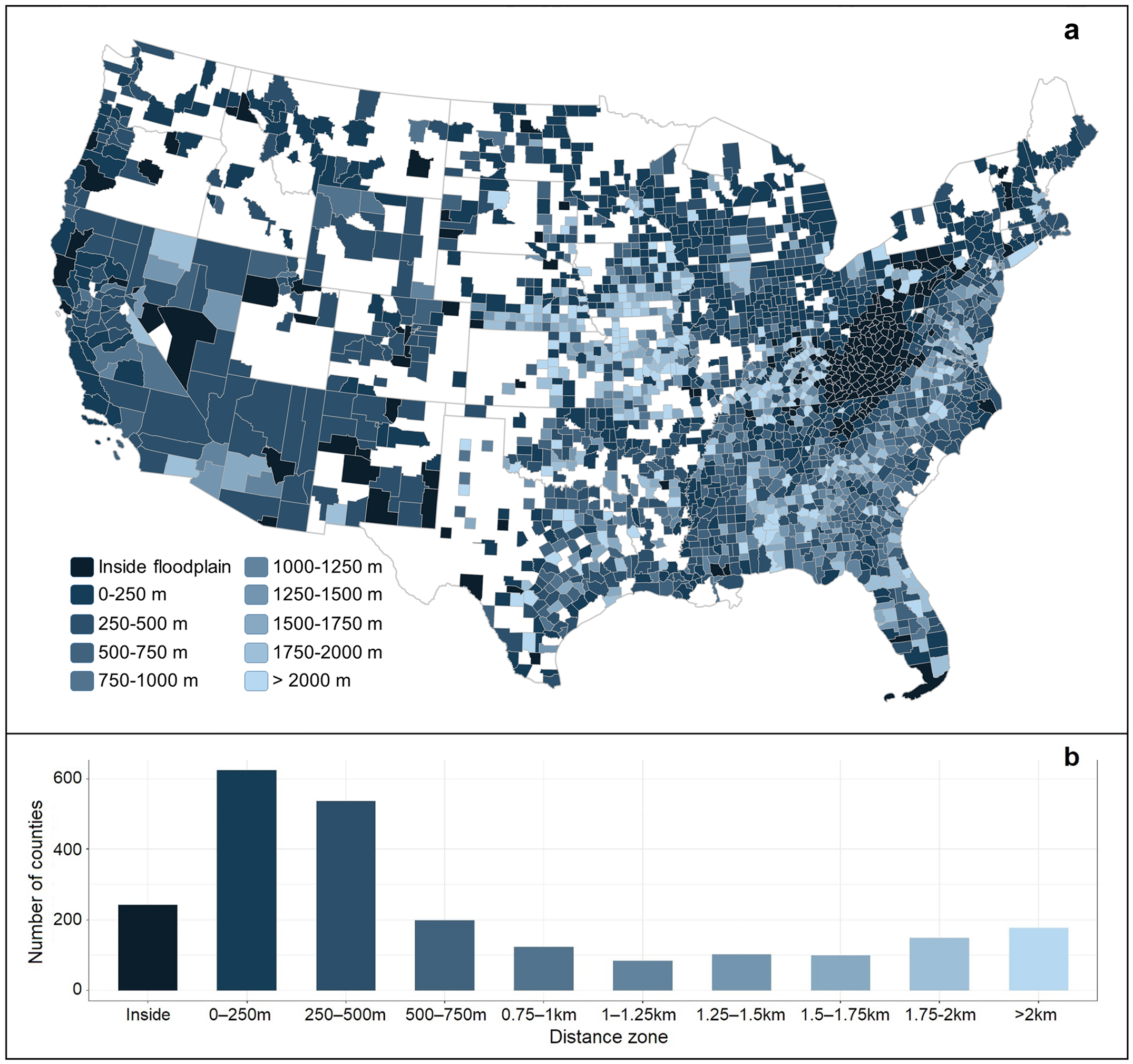
In eastern North Carolina, frequent flooding from hurricanes and sea level rise can damage soils in the floodplain, rendering the land unsuitable for crops. MGIST student Jon Owens collaborated with NC Sea Grant to identify the abandonment of once-productive farmland 1996–2019, measuring its conversion into other land cover types including urban, forest and wetlands.
At NC State University, not all classrooms are used equally, and determining how best to use campus space is of key importance to the university’s Campus Planning and Strategic Investment department. MGIST student Cameron Renfro partnered with NC State University Facilities to create an interactive web mapping application that can identify, and spatially represent, the classrooms seeing the lowest overall use.
Expanding solar energy generation is important to companies like NextEra Energy, but solar farms can’t be built just anywhere. MGIST student Michael Strunin works for NextEra as a LiDAR data scientist, and, for his capstone, he developed a method to streamline data processing and geospatial analyses, including terrain and slope analysis, to quickly assess properties for their suitability as solar farms.
Like many places across the United States, North Carolina’s Wake County is facing a school bus driver shortage. To help relieve pressure on its strained transportation service, MGIST student Hailey Tuttle developed a web mapping application for the Wake County Public School System that identifies areas within a selected walking distance from each school and the potential to assign students within those zones to schools closer to their homes. The analysis “gives us a quantitative measure of how many students could shift away from using bus transportation,” Tuttle explains.
Thank you to all of our capstone partners, and congratulations to all of our graduating MGIST students on their success!