Ian Warr: Through the Woods and Wetlands
The triangle region of North Carolina is one of the fastest growing areas in the country (Census.gov). Tens of thousands of people are moving here every year. To compensate for this growth, new developments are popping up left and right. Places that used to be rural twenty years ago are now full of urban activity. As major infrastructure projects continue to cut through what used to be farmland and forest, it can seem there is no limit to this expansion. There are, however, still many hidden pockets of nature preserved in the midst of this development. Since September of 2021, I have had the opportunity to explore these areas as an intern with Sage Ecological Services.
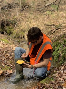
Sage Ecological Services is a small company with about a dozen full time employees. The company is in the business of environmental consulting, and currently the business is booming. When someone wants to develop a piece of land, there are certain rules that must be followed in order to ensure the protection of natural resources. Much of these protections are surrounding waterways (streams, rivers, etc) and wetlands. For example, if a developer purchases a piece of property that has a jurisdictional (meaning protected) stream on it, there will likely be a buffer in place restricting development to a certain distance from the stream. These buffers vary widely depending on the local and state laws, but they set out to accomplish the same goal: protect natural resources. Our job at Sage Ecological is essentially to find these streams and wetlands, and determine where their borders lie. This process is generally known as wetland delineation. While this may appear simple at first glance, I assure you, it is anything but. In order to accurately delineate a wetland, scientists must rely on comprehensive knowledge of hydrology, a near-encyclopedic ability to identify plant species, and extensive experience examining soil samples. You may be wondering, why are all these skills necessary? If you’re anything like me, you would have always imagined wetlands as very clearly defined swamps or marshes. However, this is often not the case.
So what makes a wetland? Well, there are several major factors to consider when deciding if an area is ‘wet’ or not. First you should ask; are there any indicators that water is present or frequent in the area? This could be as obvious as seeing standing water, but often requires looking for more subtle clues. Moss lines on trees, crayfish burrows in the mud, and water-stained leaves are all examples of hydrological indicators of a wetland. Another important factor to consider in wetland delineation is vegetation. Some plants are much more likely to grow in wet areas than others. For example, black willow (Salix nigra) is often found growing in wet soils. The presence of such a plant is an indicator that you may be looking at a wetland. Of course, it is important not to put too much emphasis on the presence of vegetation. Plants don’t care about how we classify them and will grow wherever they can. I often encounter upland (dryer soil) plants growing in wet areas and vice versa. Finally, what is generally considered the most important indicator of a wetland, is whether or not the soil is hydric. This is determined by using an auger shovel to extract a soil core, then observing the color of the sample. Certain colors (usually gray) indicate a more hydric soil than others. If you dig into the earth and pull up a bright red soil core, you are probably not in a wetland (at least in North Carolina). This is, for the sake of time, an oversimplification. In reality there are many small details to consider when delineating wetlands which I haven’t included. Utilizing these skills, the scientists that I have had the opportunity to work with at Sage are able to effectively delineate wetlands, create maps of these resources through GIS, and report their findings to the regulating agencies.
Now that you understand the basics of what makes a wetland, you may be surprised (just as I was) to find that they are all around us. Since the start of my internship with Sage, I have completely changed my perspective towards natural areas in my hometown. Before, I would’ve never thought that patches of woods on the side of I-40 could be filled with ecologically valuable, buffered wetland areas. I now find myself zoning out on walks and drives around Raleigh, wondering what pieces of nature are hiding in plain sight.
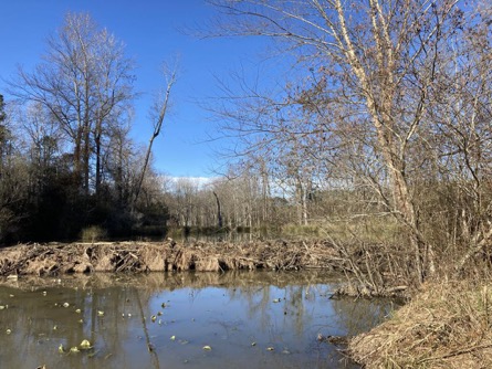
My favorite project thus far was a site in Knightdale, pictured above. A massive beaver dam had turned what was once a stream into a wetland area, submerging much of the vegetation and allowing for unique plants to grow. This project was challenging, but also very rewarding, as I could see direct evidence of the natural resources and wildlife that our efforts were protecting. I also sighted two bald eagles flying above the site that day, one of which appeared to be carrying a small mammal! Getting to see natural wonders like this is without a doubt, my favorite part of this work.
While it has been an all-around wonderful experience, I should note that this line of work is not always a walk in the park. For every pretty view like the one pictured above, there are hours of pushing through thick briars and vines. I once found myself so entangled in the thorns of a blackberry bush that I had to spend nearly half-an-hour maneuvering my limbs to avoid being turned into a pin-cushion. There is also the issue of mosquitos. One should never underestimate the willingness of mosquitos to attack every millimeter of exposed skin. Sometimes these challenges will test your patience, work ethic, and love for the outdoors. Despite this, I have always felt as though my coworkers at Sage have my back. Like I said, this is a small company. Oftentimes it feels more like you are working with friends than coworkers. The training I have received along with the willingness of everyone to show me the ropes has been what has really made this experience positive. When I started I could hardly differentiate an oak tree from a sycamore. Now, I find myself identifying just about every tree I come across. It is safe to say the skills and experiences that I have gained here will help me throughout my career and I am very grateful for this opportunity. I would encourage any environmental sciences or natural resources students to seek out this kind of internship.
Sources:New Census Bureau Estimates Show Counties in South and West Lead Nation in Population Growth. Census.Gov. Retrieved April 19, 2022, from https://www.census.gov/newsroom/press-releases/2019/estimates-county-metro.html