FUTURES Urban Growth Model
FUTURES is an open source urban growth model specifically designed to capture the spatial structure of development. Learn how you can use FUTURES in your own research.
What is FUTURES?
FUTURES is the FUTure Urban-Regional Environment Simulation and was developed by the Landscape Dynamics Group led by our Center’s director, Ross Meentemeyer. The simulation was designed specifically to address the regional-scale ecological and environmental impacts of urbanization and is one of the few land change models developed to explicitly capture the spatial structure of development. It can accommodate the input of a variety of datasets with different spatial extents and can be coupled to other models.
How do I use FUTURES?
Developers at the Center for Geospatial Analytics have made it possible to run FUTURES using open source GRASS GIS on Linux, Windows and Mac OS. Use the materials below to get started.
How to cite the FUTURES model in your work
Resources
- Online manual detailing r.futures submodels, datasets, and supplementary information for implementing FUTURES in GRASS GIS: Read the manual
- GitHub repository for FUTURES: Check the development
- FUTURES release postings: See the latest version
- Data releases provide projections of future patterns of urbanization:
- Online forum for announcements, discussion and posting questions: Join GitHub Discussions
Tutorials
- FUTURES tutorial on GRASS Wiki: Step-by-step instructions and datasets
- US-IALE 2019 workshop FUTURES land-change modeling for evaluating innovative conservation scenarios held in Fort Collins, Colorado, April 9, 2019: Step-by-step instructions and datasets
- US-IALE 2016 workshop Spatio-temporal Modeling with Open Source GIS: Application to Urban Growth Simulation using FUTURES held in Asheville April 3, 2016: Step-by-step instructions and datasets
Who do I contact for more information?
Have a modeling question? Ask it in the online forum.
Encountered a problem? First, check the FAQs; if you can’t find your solution there, report the issue on GitHub.
Want to collaborate with our developer team? Contact Center for Geospatial Analytics executive director Ross Meentemeyer, who oversees FUTURES research at the center.
What can FUTURES do?
The 2013 publication introducing FUTURES describes how the simulation works and presented the first case study for its use:
- Meentemeyer, R.K, W. Tang., M.A. Dorning, J.B. Vogler, N.J. Cuniffe, and D.A. Shoemaker. 2013. FUTURES: multilevel simulations of emerging urban–rural landscape structure using a stochastic patch-growing algorithm. Annals of the Association of American Geographers 103(4):785-807.
This publication has been cited dozens of times, and the model has been used in a variety of applications.
In 2016, we integrated FUTURES with open source GRASS GIS and described the advantages of this new approach:
- Petrasova, A., V. Petras, D. Van Berkel, B.A. Harmon, H. Mitasova, and R.K. Meentemeyer. 2016. Open Source Approach to Urban Growth Simulation. The International Archives of the Photogrammetry, Remote Sensing and Spatial Information Sciences, Volume XLI-B7:953-959.
In 2017, we compared FUTURES with several other land change models to examine tradeoffs in quantity, allocation and configuration accuracy:
- Pickard, B., J. Gray, and R. Meentemeyer. 2017. Comparing quantity, allocation and configuration accuracy of multiple land change models. Land 6(3):52–72.
In 2019, we made new advancements to FUTURES that harness parallel computing to project urban growth and landscape change at fine resolution over large extents (multi-state, regional):
- Van Berkel, D., A. Shashidharan, R.S. Mordecai, R. Vatsuvai, A. Petrasova, V. Petras, H. Mitasova, J.B. Vogler, and R.K. Meentemeyer. 2019. Projecting Urbanization and Landscape Change at Large Scale Using the FUTURES Model. Land 8(10), 144; https://doi.org/10.3390/land8100144
At the Center for Geospatial Analytics, use of FUTURES has mainly focused on research concerning conservation and ecosystem services. For example:
- Dorning, M.A., J. Koch, D.A. Shoemaker, and R.K. Meentemeyer. 2015. Simulating urbanization scenarios reveals tradeoffs between conservation planning strategies. Landscape and Urban Planning 136:28-39.
- Pickard, B.R., D. Van Berkel, A. Petrasova, and R.K. Meentemeyer. 2017. Forecasts of urbanization scenarios reveal trade-offs between landscape change and ecosystem services. Landscape Ecology 32:617-634.
- Shoemaker, D.A., T.K. Bendor, and R.K. Meentemeyer. 2019. Anticipating trade-offs between urban patterns and ecosystem service production: Scenario analyses of sprawl alternatives for a rapidly urbanizing region. Computers, Environment and Urban Systems 74:114-125.
- Sanchez, G.M., A. Terando, J.W. Smith, A.M. Garcia, C.R. Wagner, and R.K. Meentemeyer. 2020. Forecasting water demand across a rapidly urbanizing region. Science of the Total Environment 730: 139050.
The development of a new CLIMATE FORCING submodel for FUTURES 3.0 allowed accounting for human adaptation to flood risk when modeling future development, offering a more realistic assessment of future flood risk:
- Sanchez, G.M., A. Petrasova, A., M.M. Skrip, E.L. Collins, M.A. Lawrimore, J.B. Vogler, A. Terando, J. Vukomanovic, H. Mitasova, and R.K. Meentemeyer. 2023. Spatially interactive modeling of land change identifies location-specific adaptations most likely to lower future flood risk. Sci Rep 13, 18869.
Computational Steering of FUTURES
An award-winning method to interact with and steer geospatial models like FUTURES in real time has been developed by doctoral student Ashwin Shashidharan (jointly advised by Raju Vatsavai, the center’s associate director of spatial computing and technology, and center director Ross Meentemeyer). His computational steering techniques allow users to pause, play, rewind, and add new information to a geosimulation as the model is running. (Note that this experimental code is not integrated in the GRASS GIS implementation of FUTURES.)
Several publications introduce methods for computational steering with FUTURES using one computer or using distributed cores in a High Performance Computing (HPC) framework.
- Shashidharan, A. 2016. Computational steering for geosimulations. SIGSPATIAL Special 8(3):7–8.
- Shashidharan, A., R.R. Vatsavai, A. Ashish, and R.K. Meentemeyer. 2017. tFUTURES: Computational steering for geosimulations. SIGSPATIAL ’17 Proceedings of the 25th ACM SIGSPATIAL International Conference on Advances in Geographic Information Systems.
- Shashidharan, A., R.R. Vatsavai, D.B. Van Berkel, and R.K. Meentemeyer. 2018. FUTURES-AMR : Towards an Adaptive Mesh Refinement Framework for Geosimulations. In GIScience (pp. 1–15).
Integration with Agent-Based Models
New work recently introduced a hybrid agent-based modeling (ABM) – cellular automata (CA) modeling approach that integrates an ABM with FUTURES. The approach was developed to analyze dynamic feedbacks between landowners’ decisions to sell their land to developers and patterns of landscape fragmentation (note that this experimental code is not integrated in the GRASS GIS implementation of FUTURES):
Koch, K., M.A. Dorning, D.B. Van Berkel, S.M. Beck, G.M. Sanchez, A. Shashidharan, L.S. Smart, Q. Zhang, J.W. Smith, and R.K. Meentemeyer. 2019. Modeling landowner interactions and development patterns at the urban fringe. Landscape and Urban Planning 182:101-113.
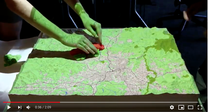
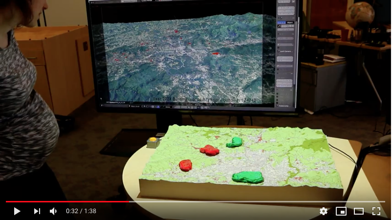
Interaction with Tangible User Interfaces
Researchers at the Center for Geospatial Analytics have also integrated FUTURES with the center’s signature tangible user interface system, Tangible Landscape. The videos below demonstrate some of the system’s uses for interacting with FUTURES and visualizing outputs.